The Wood Buffalo region covers a huge area, but you can experience its best highlights in a clear, well-paced sequence. This one-week route begins in Fort McMurray and gradually leads you toward quieter lakes, dune country, and one of Canada’s most impressive national parks. It’s built from firsthand travel knowledge and practical on-the-ground details. The goal is to help you explore confidently without unnecessary detours.
Your Journey, Step by Step
Here’s a simple breakdown of how the trip flows. Each stop builds on the previous one, moving from easy city access to deeper wilderness, so you always know what comes next and why.
Stop | What It Offers | Why It Fits Here |
|---|---|---|
1. Fort McMurray | Base city, supplies, Fort McMurray Northern Lights | Start here, acclimatize, prepare gear |
2. Birchwood Trails | Forest paths, fitness stations | Easy warm-up before remote areas |
3. Mac Island / MacDonald Island Park | Recreation facilities | Good rest/indoor day |
4. Gregoire Lake | Accessible lake, beach, camping | Low-effort nature stop |
5. Athabasca Sand Dunes | Moving dunes, wildlife | Transition to backcountry terrain |
6. Fort Chipewyan | Historic lake settlement | Cultural centre + park gateway |
7. Wood Buffalo National Park | UNESCO wilderness | Final deep-nature stage |
This ordering minimizes backtracking and increases safety by placing remote destinations later in the journey.
1. Fort McMurray – The Essential Starting Point
Fort McMurray is the only place in the region where travellers can reliably purchase gear, book hotels, and gather supplies before entering remote areas. It also sits under one of the strongest Auroral bands on the continent. If you want to see the northern lights, this is the most accessible area to try.
Aurora Viewing Checklist
- Best time: 9 pm-3 am, with midnight often ideal
- Leave town to escape light pollution
- Face north / northeast
- Bring warm layers and a thermos
- Use a tripod for long-exposure photography
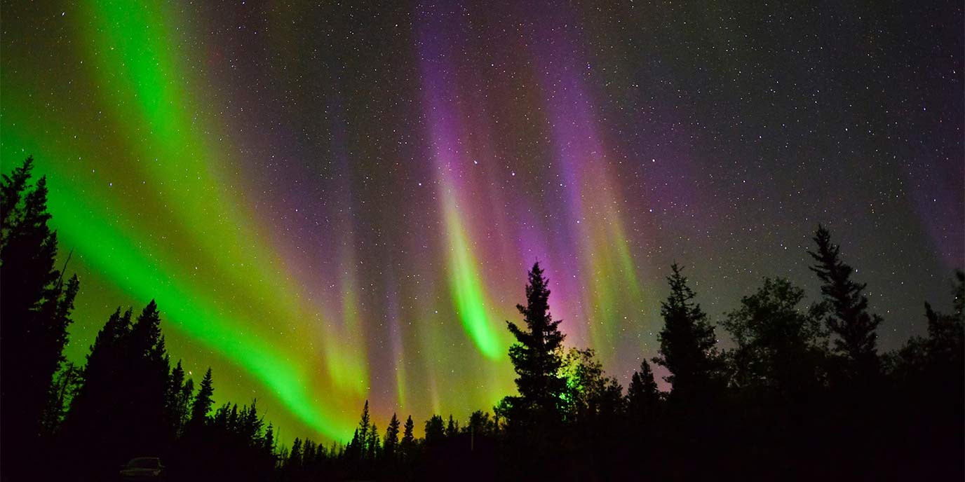
On our last visit, the sky over the highway pulled into deep green waves just after midnight – it appeared without warning, which reminded us how unpredictable and rewarding northern nights can be. This initial stop is also where you’ll return between side trips, making it the natural anchor for the entire route.
2. Birchwood Trails – The Best Local Warm-Up
Before long drives or winter-road travel, spend an hour or two walking the Birchwood Trails, a 130-kilometre network carved through the Con Creek valley. It’s an easy introduction to the region’s forest environment without leaving city limits.
Why Birchwood Works Well Early in the Trip
- Helps you adjust to northern temperatures
- Offers gentle hiking or running before backcountry terrain
- Gives families/kids a soft start
- Quick access from most hotels
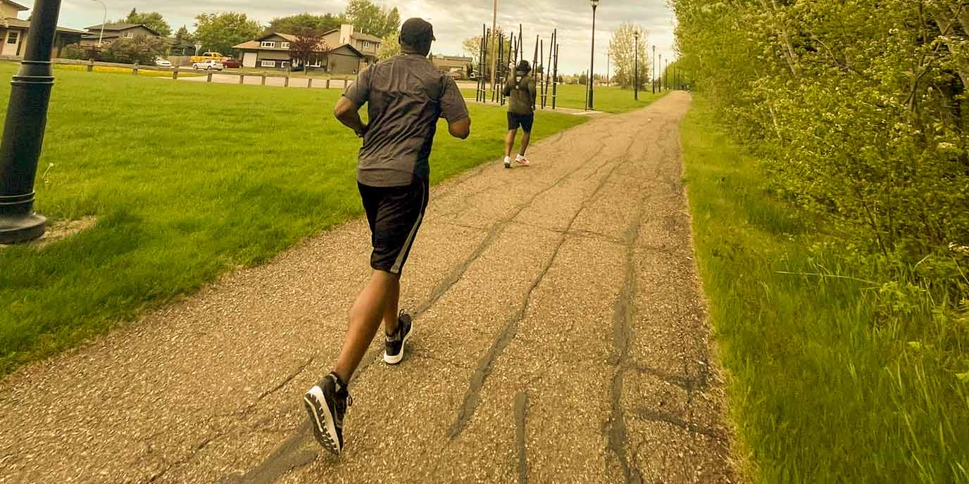
The trails smell of spruce and damp soil early in the morning, and it’s often the first moment you feel truly “in the North.” There’s also an outdoor green gym running from Cornwall Road to Woodland Drive, which is useful if you like structured workouts during travel.
3. Mac Island (MacDonald Island Park) – Your “Reset Day”
Locals call it Mac Island, but visitors will recognize it as MacDonald Island Park – the largest community recreation centre in Canada. After flights, late-night aurora hunting, or long drives, this is the perfect place to reset.
Things to Do Here
- Swim or relax at the Suncor Community Leisure Centre
- Play a round at Miskanaw Golf Club in warm months
- Use indoor turf, courts, or the climbing facility
- Catch local events or sports games at Shell Place
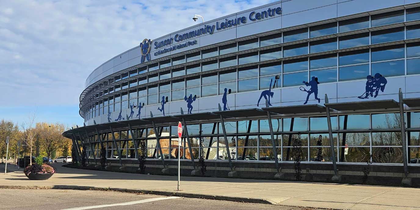
This stop prevents traveller fatigue and gives you a safe indoor day before venturing south or north.
4. Gregoire Lake – A Calm, Easy Nature Stop
Just 30-60 minutes south of Fort McMurray sits Gregoire Lake, historically known as Willow Lake. This is where you shift from “city nature” to “lake nature” without giving up convenience.
What Makes This Stop Useful
- Sandy beaches for swimming
- Barbecue areas and open space
- Safe, established campgrounds
- Calm water for paddling or small boats
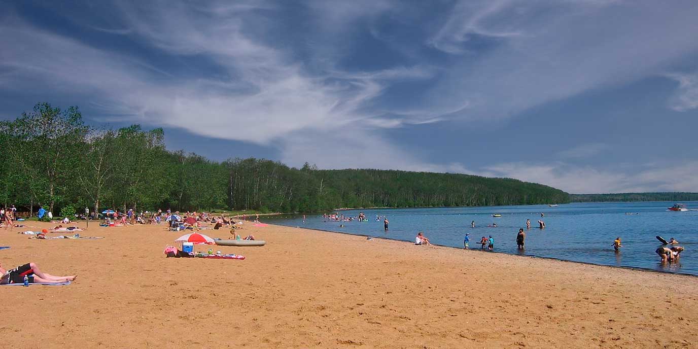
On warm days, the lake is so still that canoe paddles barely leave a ripple – it’s the kind of place where you end up staying longer than planned. This is the perfect place for families, beginner campers, or anyone who wants a slower day before heading deeper into the North.
5. Athabasca Sand Dunes – Alberta’s Moving Desert
From Fort McMurray, follow the winter road north to reach the incredible Athabasca sand dunes, one of the most surprising natural environments in the province. Few people expect to find desert-like landscapes here, but these sand dunes Alberta style formations move as much as 1.5 metres per year.
What You’ll Experience
- Tall dunes surrounded by jack pine, bogs, lakes
- Wildlife such as fox, lynx, moose, beaver, muskrat
- Excellent birding in dune-edge wetlands
- Rustic lakeside camping (pack out everything)
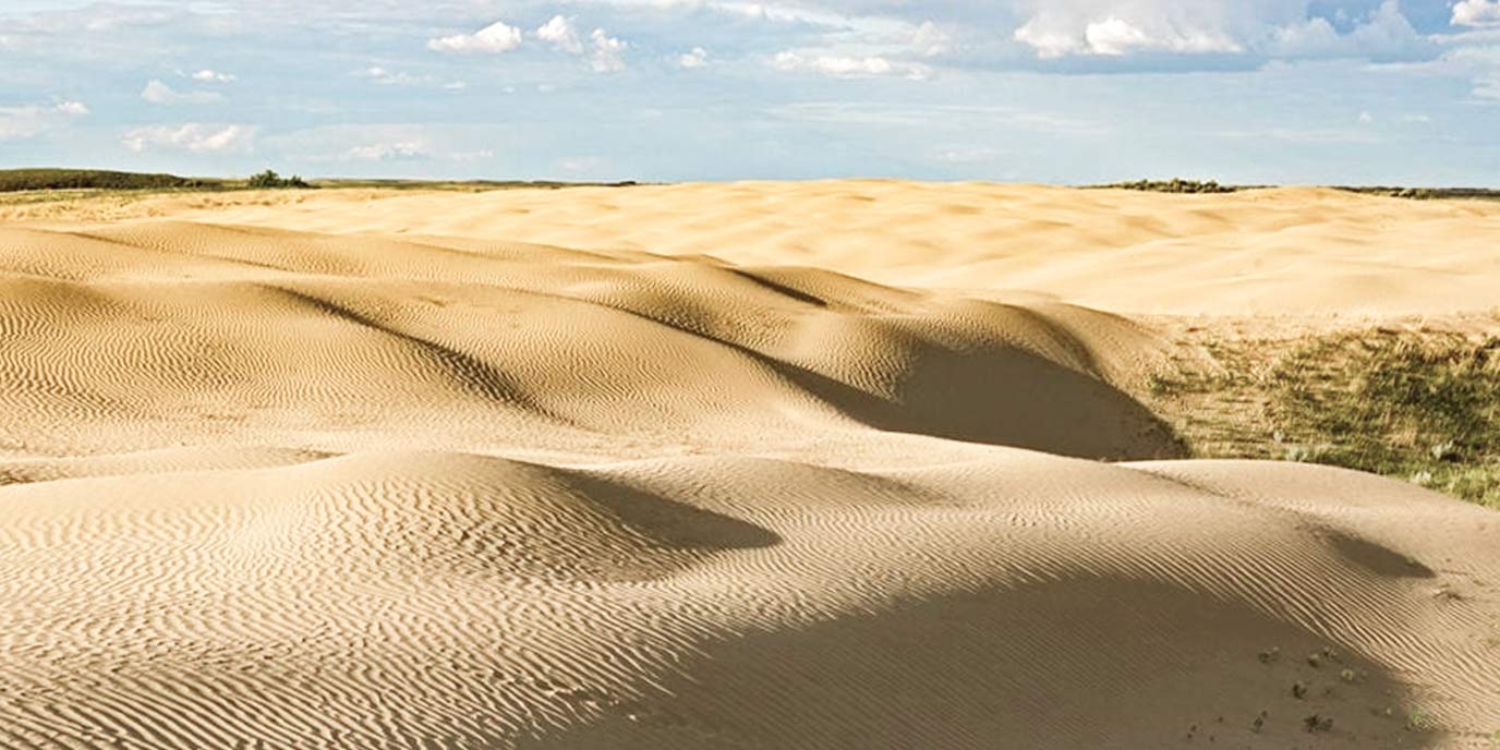
Walking here feels unreal – the sand is warm underfoot, but a few steps later you’re back on cool moss or pine needles. It’s one of the strangest transitions in northern Alberta.
For Adventurous Travellers
The area is popular for Athabasca Sand Dunes ATV trips along the Richardson River Sand Dunes Access Trail. Note that motorized vehicles are not allowed inside the protected park, but the perimeter route is well marked in summer and winter. This area marks your transition from accessible lakes to true northern backcountry.
6. Fort Chipewyan – The Historic Heart of the North
Continuing north brings you to Fort Chipewyan Alberta, one of the oldest settled communities in the province. Founded in 1788 as a Northwest Company post, it remains deeply connected to Lake Athabasca and regional Indigenous cultures.
Why This Stop Is Essential
- You experience the region’s fur-trade and cultural history
- You can visit Bicentennial Museum
- The pace slows dramatically – ideal before entering the park
- It is the main gateway into the next stage of your route
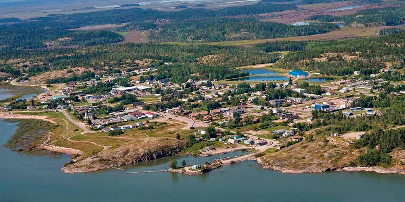
Getting There
- Summer: 40-minute flight or boat from Fort McMurray
- Winter: 280-kilometre winter road (check hotline first)
Fort Chipewyan feels like stepping into another era, and this shift prepares you mentally for the immersive wilderness that follows. It’s the kind of place where people greet you on the street, and stories come up naturally – every conversation seems tied to the land or lake.
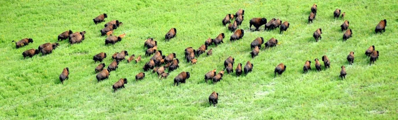
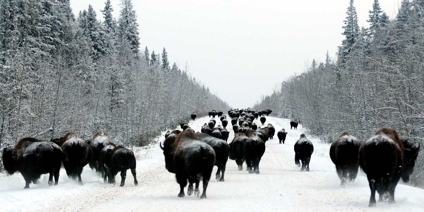
7. Wood Buffalo National Park – The Wilderness Finale
From Fort Chipewyan, continue into Wood Buffalo National Park, Canada’s largest national park and one of the most scientifically significant protected areas on the continent.
What Makes the Park Globally Important
- Home to the largest free-roaming wood bison herd
- One of the only nesting sites for endangered whooping cranes
- Peace–Athabasca Delta: the continent’s largest inland freshwater delta
- A designated Dark Sky Preserve with exceptional stargazing
Recommended Trails
Trail | Distance | What You See |
|---|---|---|
Salt Plains Switchback | 500 m | White mineral flats + surreal landscape |
Karstland Loop | 750 m | Sinkholes, karst formations |
South Loop | 9 km | Creekside walk to Grosbeak Lake |
North Loop | 7.5 km | Escarpment views + geological features |
Even after several trips, the silence in Wood Buffalo still catches me off guard – there are moments when you hear nothing but wind and the distant wings of a bird you can’t see. For camping, Pine Lake offers rustic sites with a quiet boreal setting.
Suggested 7-Day Sequence (Quick Version)
- Day 1: Arrive in Fort McMurray + evening aurora
- Day 2: Birchwood Trails + Mac Island
- Day 3: Gregoire Lake day trip
- Day 4: Drive toward dunes; overnight near backcountry access
- Day 5: Athabasca Sand Dunes exploration
- Day 6: Continue to Fort Chipewyan
- Day 7: Enter Wood Buffalo National Park
This travel overview is based solely on our personal experience, independent research, and publicly available regional information. We are travel enthusiasts, not representatives of any tourism authority, service provider, or official organization mentioned in this article. All locations, facilities, routes, and activities are described for general informational purposes only. Conditions in northern Alberta can change quickly – travellers should always verify current access, safety updates, road status, and park regulations directly with local authorities or official operators before planning their trip.